


Areas Covered by the Southern Steelhead Coalition

The expanded coalition area covers 13 watersheds from the Santa Maria River to the Santa Monica Mountains (see Map). For consistency and clarity, we've organized the watersheds the coalition will be serving, into Biographic Population Groups (BPG's), according to the NMFS 2012 Recovery Plan and the NMFS 2023 5 Year RW.
The Monte Arido Highland BPG (in red) includes the Santa Maria, Cuyama, San Antonio, Santa Ynez, Santa Clara, Ventura, and Calleguas watersheds.
The Conception Coast BPG (in yellow) includes the Santa Barbara Coastal watershed.
The Santa Monica Mountains BPG (in blue) includes the Big Sycamore Canyon Creek, Arroyo Sequit, Malibu Creek, Las Fores Canyon Creek, and Topanga Canyon Creek watersheds.
The Santa Clara River Watershed
The Santa Clara River watershed, the ancestral land of the Chumash and Tativiam, covers approx. 1,600 square miles that drains parts of several coastal ranges in the Transverse Range including the San Gabriel, TopaTopa and Santa Susanna ranges
This river system is extremely important because, in comparison to other Southern California river systems, it retains the highest degree of its natural character and landscape processes.
The major tributaries of the Santa Clara are the headwaters in the Santa Clarita Valley, Castaic Creek, Piru Creek, Sespe Creek and Santa Paula Creek.

Map of the Santa Clara watershed.
Sespe Creek is the longest stretch of undammed river In Southern California and a protected Wild and Scenic River. Sespe Creek is a big reason why the Santa Clara River watershed is critical to the long-term survival of many native species.
Even with about 50% of the total watershed area in public ownership, primarily in Forest Service Lands (Los Padres and Angeles National Forest are the green areas in map above) the Santa Clara River has not escaped the impacts of human land use and development.
Santa Ynez Water Basin
The Santa Ynez River Watershed drains approximately 896 square miles. The river originates in the Los Padres National Forest and drains the northern slope of the Santa Ynez Mountains and the southern slope of the San Raphael Mountains.
It runs about 92 miles to the Pacific Ocean near Lompoc, California. Southern California steelhead trout were abundant in the river prior to the completion of the Gilbratrar Dam in 1920, which blocked passage to the upper watershed.
The Bradbury Dam (forming Cachuma reservoir) built in the early 1950’s, further impeded the return of the steelhead. Rainbow trout source populations still do exist above the Bradbury Dam.

Map of the Santa Ynez River drainage basin in Santa Barbara and Ventura Counties, California. Made using USGS National Map data (from Wikipedia).
The SSC is now expanding into the Santa Ynez water basin. The Santa Ynez water basin and river is an important habitat for southern steelhead. We are looking for new partners and coalition members in the Santa Ynez.
If you are interested in joining the coalition as a member or partner feel free to email us at southernsteelheadcoalition@caltrout.org
Ventura Water Basin
The Ventura River and its tributaries drain a coastal watershed in western Ventura County. The watershed covers a fan-shaped area of 235 square miles, which is situated within the western Transverse Ranges (the only major east-west mountain ranges in the continental U.S.). From the upper slopes of the Transverse Ranges, the surface water system in the Ventura River watershed generally flows in a southerly direction to an estuary, located at the mouth of the Ventura River. Groundwater basins composed of alluvial aquifers deposited along the surface water system, are highly interconnected with the surface water system and are quickly recharged or depleted, according to surface flow conditions. Topography in the watershed is rugged and as a result, the surface waters that drain the watershed have very steep gradients, ranging from 40 feet per mile at the mouth to 150 feet per mile at the headwaters.
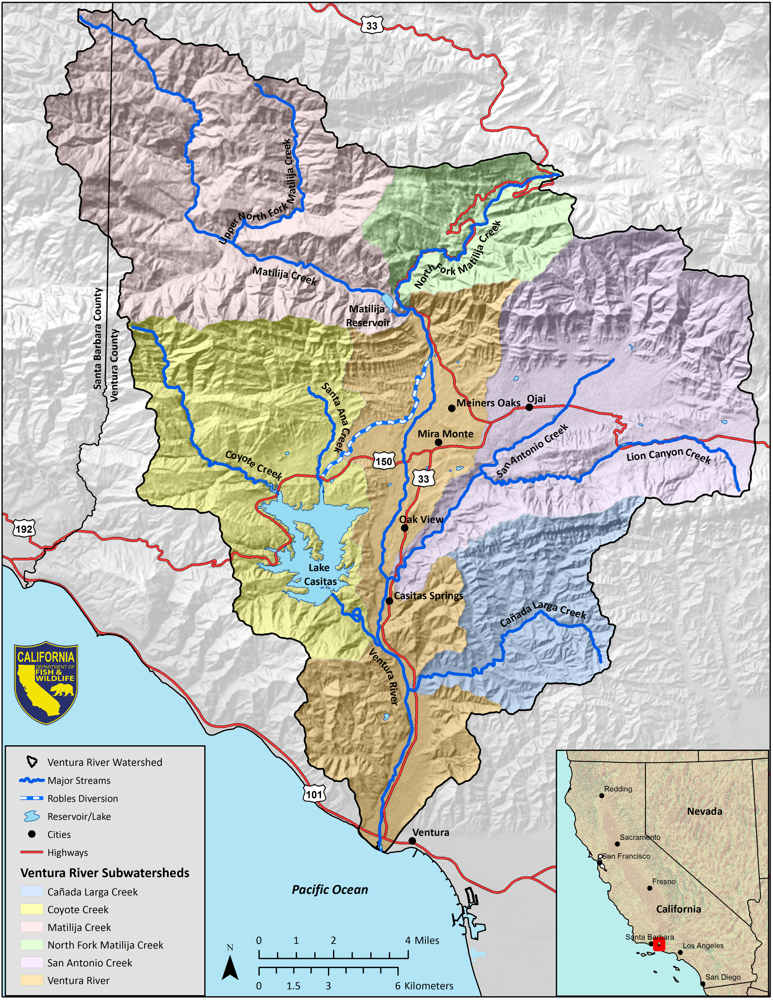
Map of the Ventura River Ventura Counties, California (from CDFW).